
It was a great four day Montana holiday with my dad. He certainly succeeded in spoiling me. Four nights in hotels, access to a vehicle, coffee on demand, and daily showers were a much needed respite from the walk. We saw a lot of sights, had a lot of laughs, ate heartily, and did plenty of relaxing. My feet enjoyed the vacation, too, and were fresh and clean coming out of Lincoln. I was as ready as I could be for the road ahead.
After connecting a miles worth of steps through Lincoln with my dad, we hugged goodbye and I switched back into walking mode. Missoula was 80 miles west. I had the luxury of seeing the road I would walk clear through to Missoula after Dad had picked me up in Lincoln.
Highway 200 follows the Blackfoot River to Missoula and was a joy to walk, with the exception of a 12 mile stretch right outside of Lincoln. The river side of the road (which I would ideally walk) was lined with a series of 12 guardrails that forced me to walk with traffic intermittently. Fortunately, there were no “double G’s” (my walker’s slang for double guardrails) which can get very dicey without adequate shoulder room.
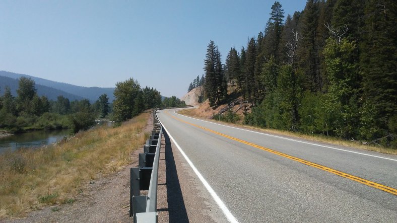
There was little or no room next to a series of guardrails along the Blackfoot River. I was forced to walk with my back to traffic for segments of a 12 mile stretch. Unnerving, but necessary!
I camped in Ovando my first night after leaving Lincoln. This friendly little Montana town caters to cross-country cyclists and the occasional walker. They have a little bike shop, cafe, general store, and a free campground. Or for five bucks, you can sleep in a teepee, covered wagon, or their historic jail building. I initially chose the wagon, but someone came and emptied the neighboring porto-potty, sending the smell into my would-be sleeping quarters. I moved to jail.
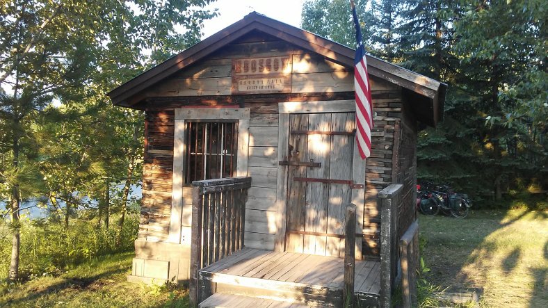
I have spent two nights in jail on my walk! The first was at the Ottawa Jail Hostel.
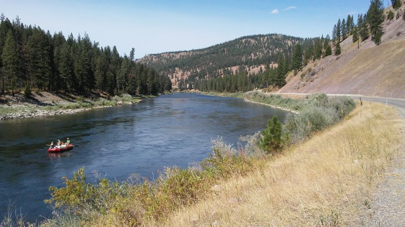
I arrived in Missoula after another two days of meandering along the Blackfoot River. I took my time getting through town. Missoula has a great college-town vibe (it is home to the University of Montana) and was a happening place even though school wasn’t in session yet. The Blackfoot empties into the Clark Fork River just outside of town. Plenty of people could be seen floating down the river in inflatable rafts, trying to stay cool. One bank temperature sign read 106.
I was on the west side of town at dusk and planned on camping near the river when I met a woman named Audrey who was out walking her dogs, Barley and Rowdy. She invited me to camp in her yard. When we arrived at her house, she asked if I needed anything. A bathroom to freshen up was at the forefront of my mind, but Audrey said she was apprehensive about me coming inside her home. Of course I understood! She brought me out a bucket of hot water and a washcloth so I was able to clean myself up a bit. Thank you for the camping spot and hot water, Audrey!
From Audrey’s yard, I was down to my last 110 miles in Montana. My route to the Idaho border was a little tricky. The interstate crossed the Clark Fork a dozen times. Some of the bridges spanning the river had shoulders, others didn’t. I wrote down directions for the first time on my walk and thought I had a plan in place that would spare me from any dangerous bridge crossings.
I walked a state highway to Frenchtown, where I began my first of several walking stints down Interstate 90. 10 miles later, I left the interstate and followed a frontage road towards Alberton, where I camped in the woods under cover of some beautiful Ponderosa Pines in Lolo National Forest.
I walked 41 miles the following day (my second 40 plus day of the walk) and camped next to the Clark Fork at a free campground five miles east of St. Regis. Unforseen construction on the interstate (which made several stretches impassable) forced me to throw my directions out the window and follow a few detours, which added four or five miles to my route. The extra miles were well worth it to stay safe!
This was the prettiest stretch of frontage road I have ever walked! The quiet road offered great views of the Clark Fork.
From St. Regis I walked to the “Route of the Olympian,” a trail that paralelled the interstate and climbed 30 miles to the Idaho border. According to Google, it was paved a few miles outside of St. Regis. Google couldn’t have been more wrong! PJ was infuriated! The trail was more of a rocky dirt road. PJ and I could barely manage 1.5 miles per hour. Fortunately, we were able to bushwack through the forest and make it back onto the smooth interstate shoulder.
I camped next to the St. Regis River near Saltese on my final night in Montana. I soaked my feet in the frigid river water just before going to sleep.
I walked the interstate over Lookout Pass and into Idaho the next day. Lookout was a relatively easy climb and offered some great views of the Bitterroot Range, despite the smoky skies. Smoke and haze in the air have become the new normal over the last few weeks. Fires burning all over the West have left the areas I’ve been traveling through blanketed in smoke. I did have one clear day between Missoula and the Idaho border in which I could actually see the forest for the trees. I have decided to pretend the area is continually covered in a layer of smoke scented fog.
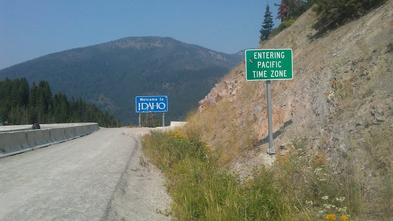
Idaho wins the award for the most scenic welcome sign! I took a nice long break atop Lookout Pass and reflected on the 32 day, 680 mile walk through Big Sky Country.
I was stoked to be in Idaho. It is always rewarding to check a state off the list, but 72 of my 90 miles in Idaho would be on a PAVED bike path. I couldn’t wait for a quiet few days of walking!
I walked downhill from the Idaho welcome sign into Mullan, then picked up the “Trail of the Coeur d’Alenes,” which spans most of the Idaho Panhandle. I arrived in funky Wallace (the self-proclaimed “Center of the Universe,”) and camped at an RV Park. I hadn’t showered in a week, and even though the water was only luke warm, it felt amazing.
Following the Coeur d’Alene Trail was an amazing way to travel through Northern Idaho. The first 25 miles passed through the silver mining towns of Mullan, Wallace, Silverton, and Kellogg. At one time, the Silver Valley of Idaho produced more silver than any other area in North and South America. From Kellogg the trail left the freeway and followed the Couer d’Alene River for 30 miles. Wildlife was plentiful on the trail. I spotted a moose, deer, an owl, osprey, blue herons, and plenty of chipmonks (which would always prompt me to yell “Alvin!”).
The final 12 miles of the trail ran along Lake Coeur d’Alene, and included a walk across the Chatcolet Bridge.
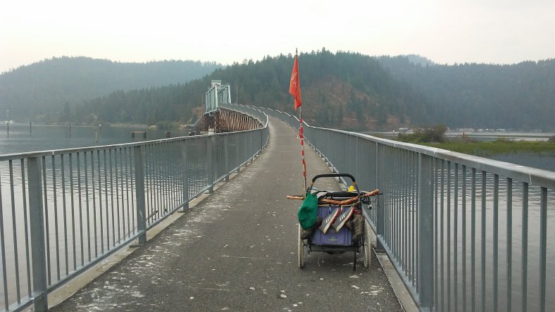
The Chatcolet Bridge was one of many highlights along the Trail of the Coeur d’Alenes.
Although the scenery along the trail was beautiful, my favorite aspect of the Trail of the Coeur d’Alenes were the people! There were plenty of other cyclists along the path, but only one bearded man pushing a stroller decorated with a giraffe and a duck. I talked to a handful of people along the way. My favorite encounter was with Shane and his three kids, Ben, Gus, and Isadora. The family lives in Eugene, Oregon, and drove to Idaho to ride the trail. Shane carried the camping gear and food on his cargo bike, while the kids carried their own clothes and water on their bikes, complete with their own little saddle bags. They biked from the west side of the trail to Kellogg and were returning to their starting point when we met. The family covered about 30 miles per day. I joined them for a snack at a trailside picnic table. The twin 7 year-old boys encouraged me to camp with them in Harrison that night. I couldn’t turn them down! I joined them for a mac’n cheese and hot dog dinner. The kids asked me a lot of questions…including some tough ones, like “what’s your favorite bug?” Their scary stories were tough to beat, too.
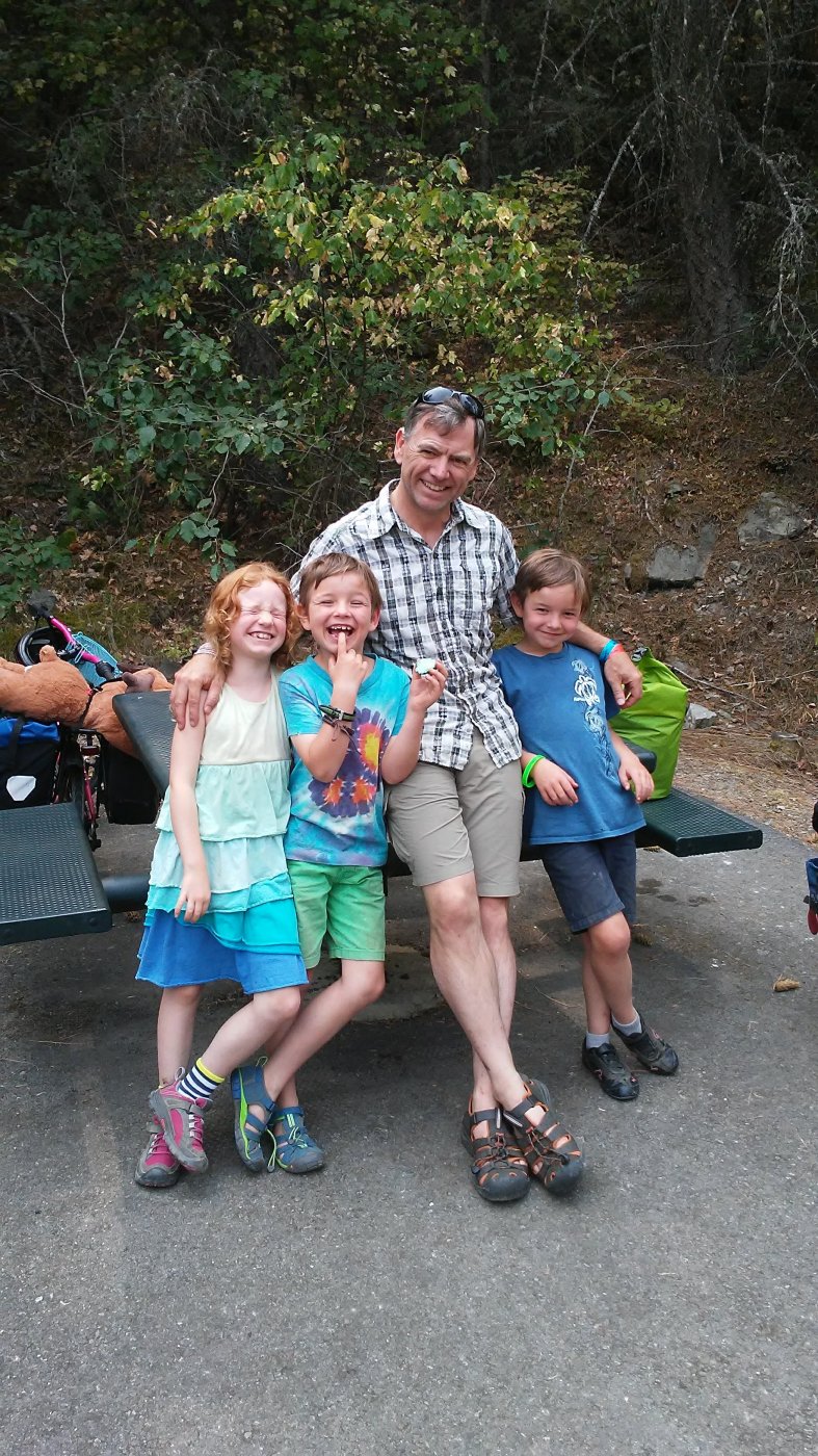
New friends on the trail!
After 32 days in Montana, Idaho took a mere three-and-a-half to cross. I arrived in my second to last state of the journey, Washington, on August 17th.
A handful of vehicles pulled over and said hello as I neared and crossed the state line last evening. A man named Larry, who has been farming in Eastern Washington for the last 58 years, bought me dinner at a little restaurant in Tekoa last night. Thank you for the great welcome to Washington!
After 10 days and 286 miles of walking since Lincoln, I was ready for a rest day! I am camping at a city park in town and spending the day off my feet, playing catch up, and planning my route through Washington.
Trip Stats
Days – 129
Miles – 2,922
Peanut Butter Jars – 101
Loose Change – $8.10
Favorite Roadside Find – About a mile from where I said goodbye to my dad, I came across a toy car and a little note underneath a stone. The note was a touching, encouraging message from my dad. He bought the car at a pawn shop in Great Falls during our visit, and I have been using the rock to pound in my tent stakes….the rock is much more effective than my metal coffee mug! Thank you pop!
Favorite Four Photos-

I’m not sure why I like this picture so much! This was taken near Alberton, MT. The railroad along the Clark Fork has been decommisioned for some time, so the rail bridge over the road no longer exists. This spot was a little eerie, especially at dusk.
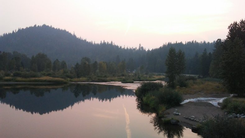
The Coeur d’Alene River near sunset.
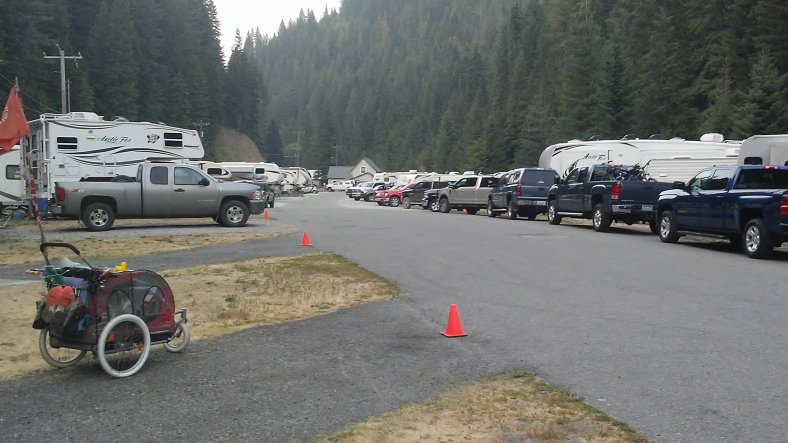
Can you guess which is my favorite vehicle parked at the Wallace RV Park for the night?
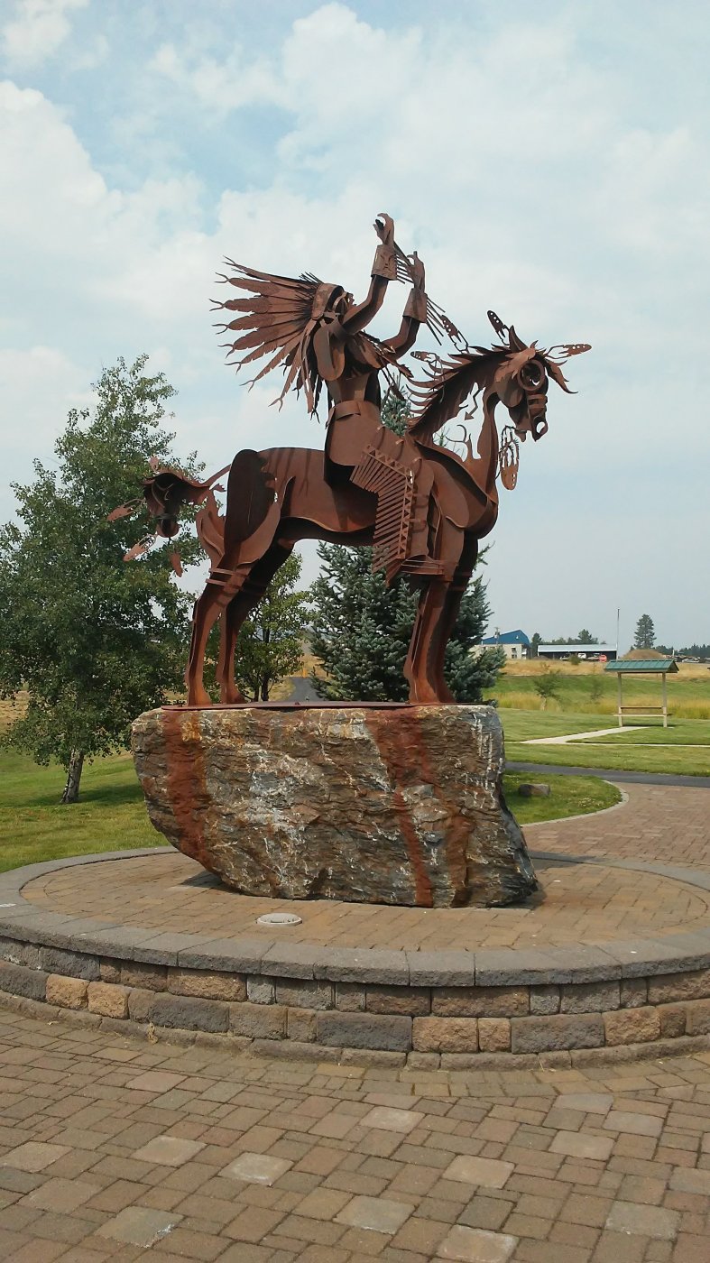
This powerful statue greets visitors at the trailhead for the Trail of the Coeur d’Alenes in Plummer, Idaho. 15 miles of the trail is on the Coeur d’Alene Reservation. The statue honors Native Americans who have died serving our country. It is a beautiful, moving piece.
From Tekoa, I am less than 500 miles from the Pacific…PJ and I will have our work cut out for us on the walk from Eastern Washington to the ocean. Increased traffic from farm vehicles (harvest season is at its peak) and college students headed back to school at Washington State, along with a hot and smoky forecast will only add to the challenges down the road. This is going to be a hell of a push to the Pacific!
Walk on!

Great update Ben. I never knew about the Idaho trail. Hopefully one day I will be able to enjoy it. Walk On!
LikeLike
Hi Ben, You sure are seeing lots of interesting terrain on your journey. I especially enjoyed the photos of Clark Fork and Trail of Coeur d’Alenes…the river is breathtaking! Carry on! Liz
On Sun, Aug 19, 2018 at 9:23 AM Walking Across America – 2018 wrote:
> Ben_Clagett posted: “It was a great four day Montana holiday with my dad. > He certainly succeeded in spoiling me. Four nights in hotels, access to a > vehicle, coffee on demand, and daily showers were a much needed respite > from the walk. We saw a lot of sights, had a lot of laug” >
LikeLike
It was a beautiful stretch, even with the smoke! I love walking by rivers! Hope all is well!
LikeLike